Change Detection: Estimating the Footprint of the Kribi Agro-Industrial and Urban Port Complex (Cameroon) from Landsat Imagery
In the coastal South region of Cameroon, 26.000 ha of land once covered by forest is doomed by the development of a significant infrastructure: the Kribi Agro-Industrial and Urban Port Complex. Important earthwork was undertaken to set-up this “structuring project” which is presented as the ultimate propeller for the industrialization of the entire Central Africa region.
This paper is the first of a series aiming to use pixel-based digital image differencing to determine the footprint of the Kribi Agro-Industrial and Urban Port Complex at its present stage of development. Hopefully it triggers sound decisions and awareness on the fate of this biome, part of the Congo Rainforest
1. Introduction
Building new harbors is a trending in Africa. Mostly financed and built by China as a part of the implementation of its 21st Century Maritime Silk Road strategy also referred to as the Belt and Road [1], these new infrastructures all ambition to become regional hubs. Are cited El Hamdania (Algeria), Doraleh (Djibouti), Bagamoyo (Tanzania), Lamu (Kenya), Maputo (Mozambique), N’Diago (Mauritania), Boké-Dapilon (Guinea), Lekki (Nigeria), Owendo (Gabon) and last, Kribi (Cameroon) which is the subject of this paper. As the intent and nature of the Kribi multi-layered project are still being widely debated, little emphasis had
been made on the environmental footprint of this endeavor.
That is precisely the focus of this paper. Since 2010, in the Coastal South region of Cameroon, the land west of the Lobé River (once covered by a very dense and diverse tropical rainforest) has been dedicated to the development of a large coastal agro-industrial and urban port complex also known as the Kribi Deep-Water Harbor, herein KDWH [2]. Long before its implementation, disagreements on the prioritization [3] [4] and
the viability of this project were voiced, its sustainability questioned, the environmental damages and their adverse effects on the indigenous communities raised. After these concerns were presumably dealt with or swept aside, the fate of this ecosystem was sealed. On December 27th, 2010, earthworks started resulting
in the first 60 ha of land been deforested for the phase 1 of the KDWH.
This project needs to be understood in relation to a specific legal, political and economic environment where no discussion on the proto-biome is deemed necessary, the capture of alterations neglected, progressions or regressions not recorded, withhold or lack of quantitative and reliable information prevalent, infringements
and unaccountability recurrent, the reconciliation of sustainability with economic growth not well understood or valued [5], drifts not decried.
This paper aims to use remote sensing capabilities and GIS spatial analysis functionalities to accurately assess damages and the ecological footprint of this project during its execution for a better environmental management of this ecosystem.
2. The Kribi Agro-Industrial Port and Urban Complex Project
The area covered by this study is in the Kribi I subdivision, Ocean division of the South region of Cameroon (Figure 1: location of the KDWH in Cameroun). It slightly encompasses the concession of the KDWH project. With a width of 10.5 km and a length of 23 km, the Area of Interest (AOI) determined here is broadly 24,786 hectares comprised of 17,084 hectares of land and 7746 hectares of ocean.
It stretches between latitudes 2˚37’31” and 2˚49’57” North, and the longitudes 9˚50’14” and 9˚56’2” East. The major physical features here are the Lobé River in the North East and the Atlantic Ocean in the West. This area is a coastal plateau, with altitude ranging from 0 to 286 m (300 m) is soaked by an equatorial climate characterized by a mean annual temperature of 26.8˚C and an annual precipitation of 2817 mm distributed in four seasons: a major dry season from November to March, a minor rainy season from March to May, a minor dry season from June to Mid-august and a major wet season from Mid-august to November. Its original flora was a moist evergreen coastal forest where noticeable dominant species were: Lophira alata (Azobe), Sacoglottis gabonensis (Ozouga), Cynometra hankei, Strombosiopsis tetrandra, Coula edulis [6] (Letouzey 1986). Before 2010, this dense forest was longitudinally crossed by the Kribi-Campo oceanshore road (N7) alongside which were the following villages: Grand Batanga II Eboundja I. Eboundja II, Nlende Dibe, Boussibelika, Mboro, Lolabe. Lohendje and, few Pygmies encampments.
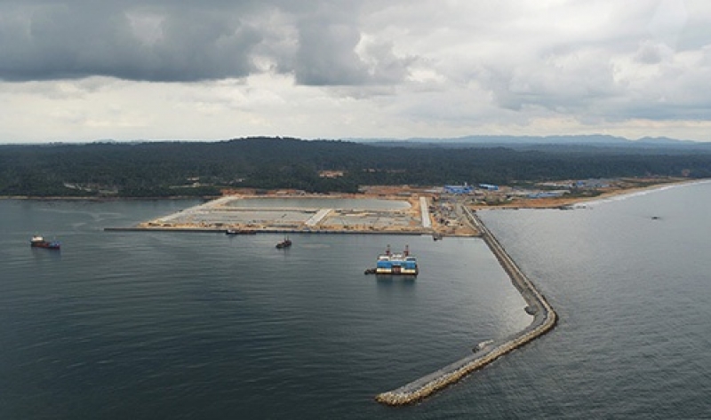
Taking advantage of the Atlantic Ocean conditions and depth of −20 m (66 ft.) at less than a hundred meters from the coastline in this area [7] [8], amidst some controversies, the government of Cameroon choose to boost the economic growth and foster the industrialization of the whole central Africa hinterland by building a deep seaport complex centered on the seaside village of Mboro [9]. The KDWH is located approximately 30 kilometers south of the coastal town of Kribi, 200 kilometers south of Douala, the oldest and busiest harbor in Cameroon.
The 25 kilometers in length industrial port complex at its completion by 2035 will be made of four main parts: a deep-water port with 20 wharfs which will be able to accommodate ships with more than 25 m draft, a zone for industrial and logistic activities (been built), a multimodal transport corridor named “backbone” (started), a not yet built new city of 100,000 inhabitants [10]. For the setting of all these infrastructures, huge excavations and other earthworks have taken place, resulting in the destruction of large portion of this land with a noticeable footprint.
Jean Megope Foonde
Department of Geography, Northern Illinois University, DeKalb, USA
Copyright © 2018 by author and Open
Access Library Inc.
This work is licensed under the Creative
Commons Attribution International
License (CC BY 4.0).
http://creativecommons.org/licenses/by/4.0/